Beautiful 25.17 Cuerdas Finca with Sea Views
$230,000
24.45 ac
Your take
What do you like?
Scout suggestions are outlined. Your choices are filled.
Notes
No notes yet.
Scout suggestion
24.45-acre property with private, views and mountain setting.
- Land only — no move-in-ready home.
- The existing structure is not move-in ready.
Listing detailsPrice, facts & description
| Location | Quebrada Yeguas, Salinas |
|---|---|
| Asking price | $230,000 |
| Property | Land only |
| Land | 24.45 acres |
| Property type | Land |
| Photos | 1 reported by Clasificados · 1 available here |
| Listing agent | (787) 633-0130 |
Description from Clasificados
Source title: Finca 25.17 cuerdas hermosa vista
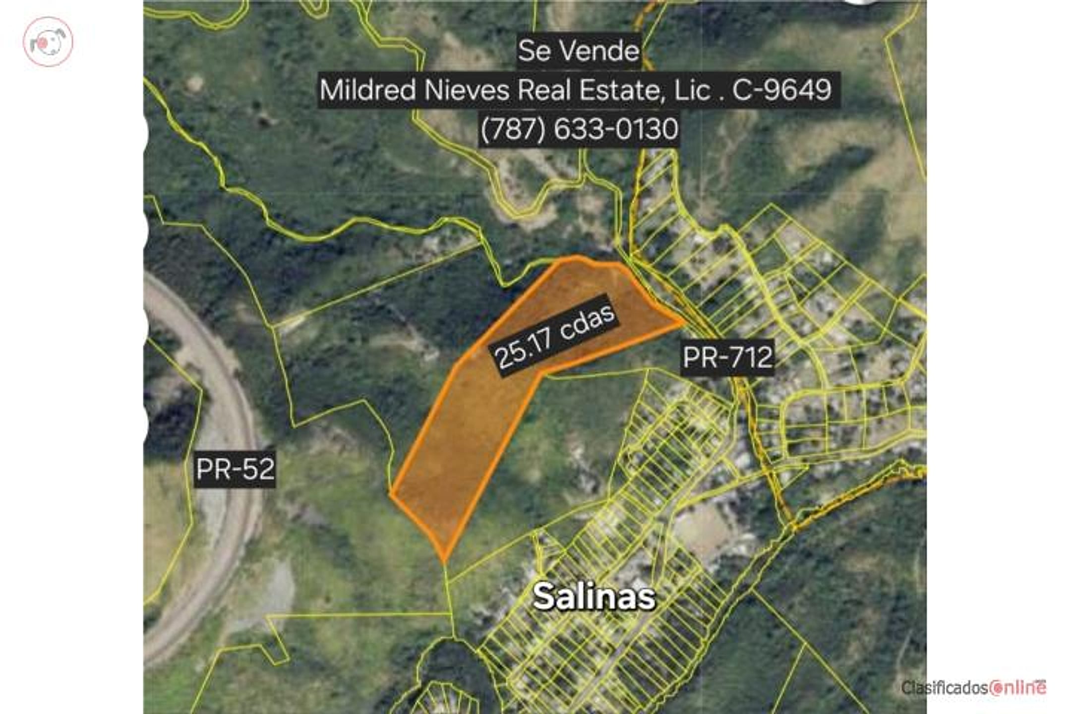
FOR SALE: Finca in Salinas, PR, in Barrio Quebrada Yeguas—a beautiful locale with terraced slopes as you ascend the mountain and sea views from the plateau, inspiring peace. Excellent for lodging, church, homes, agriculture, etc. (Agua Fría Sector, near the ball field in Sector La Plena). Total acreage: 98,943.54 square meters (25.17 cuerdas). Very close to churches, groceries, excellent location 5 minutes from the Albergue Olímpico via PR-712 Highway. On one end, it borders the PR-52 Expressway easement. Agricultural classification (AP). Sale price: $230,000.00. Contact for information and details at (787) 633-0130, Lic. C-9649. Coordinates: 18.050064, -66.204579 Puerto Rico.
SE VENDE FINCA en SALINAS, PR en el Barrio Quebrada Yeguas lugar hermoso con teraplenes según subes la montaña y vista al mar en la meseta, inspira paz! Excelente para hospederia, iglesia, casas, agricultura, etc. (Sector Agua Fria y cerca del parque de pelota del Sector La Plena), con una cabida de: 98,943.54 metros cuadrados (equivalentes a 25.17 cuerdas) muy cerca de iglesias, colmados, excelente localizacion a 5 min. del Albergue Olímpico carr. PR 712 y por el otro extremo colinda con la sevidumbre del Expreso PR-52. Clasificación AP. Precio de venta $230,000.00 Llama para informacion y detalles al (787) 633-0130 Lic. C-9649 Coordenadas: 18.050064, -66.204579 Puerto Rico
Location & driveMap, terrain & destinations
Location, terrain & flood
📍 Open in Google Maps — listing coordinates 👁 Street View 🛰 Satellite
⛰ 572 ft elevation
Exact coordinates supplied in the listing; confirm them against the parcel boundary. Elevation: USGS. Flood zone: FEMA NFHL.
Drive times
| Miramar Bar | 68 min | 46.8 mi |
|---|---|---|
| Playa Lucía Disc Golf | 56 min | 38.8 mi |
| Albergue Olímpico Disc Golf | 18 min | 4.5 mi |
| SJU Airport | 77 min | 50 mi |
| Costco (Caguas) | 49 min | 30.5 mi |
Area notes
Salinas lies south-central Puerto Rico, roughly 30–40 km southwest of Humacao (30–45 min drive). The municipio straddles coastal plains and foothills; Quebrada Yeguas barrio is in the elevated interior zone with terrain suitable for terraced agriculture and elevated home sites. Views toward the Caribbean are typical at this elevation. Salinas is outside the El Yunque rainforest belt but benefits from moderate tropical rainfall; landslide and erosion risk should be assessed on steep slopes. The area is quieter, more rural, and less flood-prone than coastal lowlands, but proximity to PR-52 expressway brings traffic noise.
CRIM & due diligenceParcel record & questions to verify
🏛️ CRIM property record
⚠️ Candidate parcel—not yet confirmed. The CRIM facts and sale history below belong to the parcel under the exact listing pin. Confirm the boundary before treating them as facts about this listing.
| CRIM parcel number | 371-000-004-12 |
|---|---|
| How it was matched | Parcel candidate from the exact listing pin and the February 2025 Planning Board parcel layer; verify in current CRIM |
| Address (CRIM) | BO PALMAS FINCA LA FRUTA , ., PR, Puerto Rico, 00751 |
| Owner of record | GORDIAN APONTE LUIS A |
| Recorded parcel size | 24.45 acres · 25.17 cuerdas · 98,927.92 m² |
| Last recorded sale | $15,000 on 2016-02-06 · seller RIOS RIVERA ANGEL · buyer LUIS A.GORDIAN APONT ⚠️ asking 15.3× the last sale |
| Registry | Finca 9112 · Tomo 229 · Folio 100 · Escritura 6 |
| Assessed value | $521 total (land $521 + structure $0) — CRIM tax basis, not market value |
| Taxable assessed value | $521 |
🏛️ Open official CRIM record Paste an MLS address or CRIM number
The public cadastre identifies the parcel and its assessed values. It does not certify that the account has no current or prior debt; request the seller's CRIM account statement and certification for closing.
Buildability
Agricultural (AP) classification supports residential construction. Terraced mountain terrain is favorable for drainage and foundation work. Borders PR-52 expressway easement on one side (may impose noise/setback constraints); road access via PR-712 appears clear. No flood risk noted, but verify drainage and any seasonal water patterns on steep slopes. Survey and municipal building permits essential.
Questions to verify
- Verify no active flood zone (FEMA) or landslide hazard zone mapping for the specific terraced slopes; steep mountain terrain can drain well but requires professional geotechnical review.
- Confirm road access and easement rights to PR-712 and any internal access road; clarify whether the PR-52 easement border imposes building setbacks or restrictions.
- Obtain a professional survey and confirm the full 25.17 cuerdas boundary, especially the easement perimeter.
- Verify AP (agricultural) zoning allows residential single-family construction without variances; check if municipal permits are readily issued.
- Inspect for existing water (spring, well, or municipal line) and septic/waste-system feasibility on the slope.
- Confirm no environmental or heritage (archaeological) restrictions apply, and obtain a Phase I environmental assessment if budget allows.
Research & sourcesPhotos, web findings & original listing
Other things spotted in the photos
AI-read from the listing photos — unverified, eyeball against the actual photo before relying on it.
- Note:
29.17 cdas— Land area measurement on property map - Address:
PR-712— Road designation on property map - Address:
PR-52— Road designation on property map - Address:
Salinas— Municipality name on property map
What the web found
A likely match was found on Island Portfolio Services (islandportfolios.com) listing a 25-cuerda finca in Hacienda Salinas with coordinates 18.05951688, -66.23145297. The listing specifies five 5-cuerda parcels, requires cash or bank prequalification, and is not subject to appraisal. The broader Puerto Rico real estate market shows strong price growth through Q1 2025, with limited land availability driving demand. Historical geologic and flood hazard data indicates the Salinas coastal area east of Laguna de las Salinas has minimal landslide risk and relatively flat terrain.
Also found online:
- Island Portfolio Services — 25-cuerda finca described as five 5-cuerda parcels in Hacienda Salinas; requires cash or bank prequalification; not subject to appraisal
Area intel: Puerto Rico's housing market has appreciated significantly (11.6% in Q1 2025, 22% in Q4 2024), driven by limited land availability in coastal areas and Act 60 tax incentives. A comparable land-with-house property in Salinas was listed for $350,000 at 11.75 acres as of March 2025. Geologically, the Salinas area east of Laguna de las Salinas has minimal landslide susceptibility and nearly flat to <10-degree slopes; however, liquefaction risk exists near the coastline in areas with shallow water tables. Coastal flooding potential is documented historically (Salinas experienced damage in the October 1985 floods).
What the sources contribute
Recorded sale history
- Feb 6, 2016 · $15,000 · seller RIOS RIVERA ANGEL · buyer LUIS A.GORDIAN APONT (CRIM Catastro Digital)
Exact-property sources
- ClasificadosOnline primary listing · Aug 3, 2026 · 12 observations retained
$230,000 · 24.45 ac · 1 photo · 18.050064, -66.204579 · (787) 633-0130 - CRIM Catastro Digital public record · Jul 31, 2026
parcel 371-000-004-12 · 1 recorded sale
Match: Official record returned for parcel 371-000-004-12.
Sources
Original listingGoogle itGoogle MapsStreet ViewSatellite viewRealtor.com compsPR flood map (FEMA)🏛️ Official CRIM record (371-000-004-12)Clasificados ID 4899368 · added 2026-07-27