254 cuerdas Beautiful Farm Between Trujillo Alto & Gurabo
Description from Clasificados
Located in Barrio Santa Rita, Quebrada Infierno, Gurabo. Property has multiple entrances, primary access via PR-851 in Barrio La Gloria, Trujillo Alto. Includes 5 three-bedroom/one-bath residential units requiring rehabilitation, an 8,000 sq ft building currently in use, and a two-story structure of approximately 2,000 sq ft. Spectacular views of the North Coast. Located 12 minutes from the urban center of Trujillo Alto and 20 minutes from the town of Gurabo. Property features quebradas (streams) and water storage tanks requiring rehabilitation. Former cattle farm (vaquería). Coordinates: 18.306514, -66.000895.
Original Spanish
Bo. Santa Rita Quebrada Infierno en Gurabo. Esta propiedad cuenta con varias entradas siendo la ClasificadosOnline principal por la Carr. 851 en el Bo. La Gloria de Trujillo Alto. La misma cuenta con 5 unidades de vivienda de tres cuartos y un baño a ser rehabilitadas. Un edificio de 8,000 pies cuadrados actualmente en uso y otro de dos niveles de aproximadamente 2,000 pies cuadrados. Vista espectacular a la costa Norte. La propiedad esta ubicada a 12 minutos del casco urbano de Trujillo Alto y a 20 minutos de Pueblo de Gurabo. Cuenta con Quebradas y tanques de almacenamiento de agua a ser rehabilitados. Antigua Vaqueria. Coordenadas 18.306514, -66.000895 Puerto Rico
Why it's interesting
This is a large, developable agricultural holding with legitimate farm infrastructure and multiple buildings, priced near mid-market for the region. However, it is fundamentally flat (57 ft elevation, coastal plains), offers no visible ocean views despite marketing claims, no observable riverfront or fruit trees, and minimal privacy value given its working-farm character and multiple road access points. The couple's stated loves (elevation, views, oceanView, rainforest) are largely unmet; the property is better suited to agribusiness or large-scale development than a dream residential retreat.
🔄 Refreshed with measured elevation/flood, the cadastre record, and the listing photos on 2026-07-01.
💵 Last recorded sale price not provided; $1.99M for 246.68 acres (~$8,070/acre) is reasonable for raw/farm land in Humacao, but verification of title chain and condition assessment of five residential units + two large structures is essential given rehabilitation claims.
What the photos show
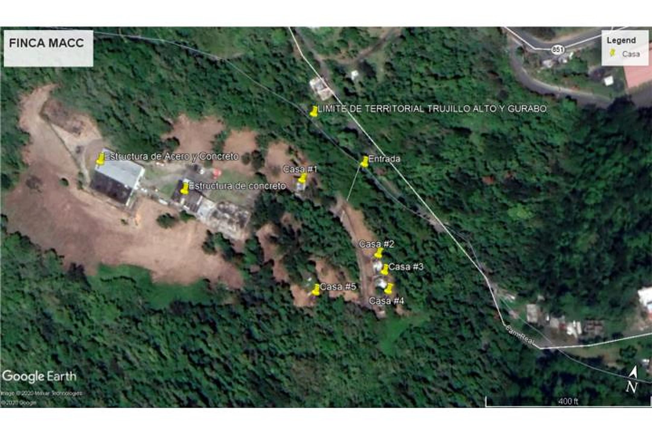
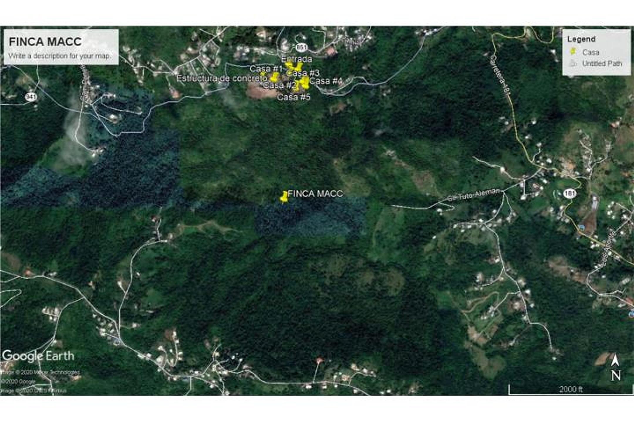
Photo 1 shows a sprawling, flat agricultural landscape with dense tropical vegetation, cleared pasture areas, and multiple structures scattered across the property—confirming the former cattle-farm character. The terrain is visibly low-lying and flat with no meaningful elevation changes; dense green forest dominates the perimeter and interior. Photo 2 is a cadastral/satellite map overlay showing the property boundary (Inca Macc labeled) in the context of surrounding forest and development, confirming the large acreage but offering no additional terrain or structural detail. Neither photo reveals ocean views, though the listing claims 'spectacular views of the North Coast'—the flat terrain and dense vegetation in Photo 1 would make such views unlikely from ground level without a tower or cleared vantage. No visible fruit trees, riverfront, or streams evident in Photo 1; structures appear weathered and in need of rehabilitation, consistent with listing claims. Road access appears adequate via cleared farm roads.
Read from the listing photos by vision AI — verify against the images yourself.
| Location | La Gloria, Humacao (tier 1 — ≤30 min of Humacao) ⚠️ listing text names a different town — verify location |
|---|---|
| Price | $1,990,000 |
| Size | 246.68 acres (254 cuerdas) |
| Land $/acre | $7,256/acre (after $200,000 home credit) |
| Fit score | 42/100 |
| Existing home | 5 three-bedroom/one-bath units needing rehab; 8,000 sq ft building in use; 2,000 sq ft two-story structure. Not move-in ready. — not move-in habitable |
Other things spotted in the photos
AI-read from the listing photos — unverified, eyeball against the actual photo before relying on it.
- Note:
DISTRITO DE TERRITORIAL TRUJILLO ALTO Y GURABO— Text visible in photo 1, top of image - Note:
FINCA MACC— Text visible in photo 2, right side of image
Location, terrain & flood
📍 Open in Google Maps — La Gloria, Humacao, Puerto Rico 🛰 Satellite
⛰ 57 ft elevation 🌊 FEMA Zone X — minimal flood
Barrio-level pin (listings give barrio + municipio, not the exact lot) — verify the parcel location. Elevation: USGS. Flood zone: FEMA NFHL.
Drive times
| Miramar Bar | 15 min | 7.9 mi |
|---|---|---|
| Playa Lucía Disc Golf | 18 min | 12.6 mi |
| SJU Airport | 64 min | 36.7 mi |
| Costco (Caguas) | 35 min | 21.1 mi |
Buildability
Scale and elevation suggest buildability, but existing agricultural zoning (former vaquería), five dispersed dwellings, and water infrastructure (quebradas, tanks) suggest this may be classified for agricultural or rural multi-unit use, not single-family residential. Will require zoning verification and possible variance.
What the web found
The property appears between Trujillo Alto and Gurabo in the greater Humacao area, a growing market with land prices ranging from $40K–$2.7M depending on location and size. Humacao is an emerging investment area with lower entry costs than luxury destinations like Dorado, and potential for appreciation through eco-tourism and resort-style development.
Also found online:
- Homes.com — General Puerto Rico land listings; no specific match to this 254-cuerda parcel found
- FindItPR.com — Trujillo Alto listings show 18-cuerda terreno for $2.7M and smaller parcels; no exact match
- FindItPR.com Humacao — Humacao land listings include 40-cuerda parcel ($315K), smaller residential lots; no 254-cuerda match
Area intel: Humacao is experiencing emerging market growth with land prices as low as $40,000 and properties up to $2.7M in nearby Trujillo Alto. Single-family homes in Humacao average ~$2.1M, condos ~$1.3M. At $1.99M for 246.68 acres, this listing sits mid-range for the area. Humacao faces multiple natural hazards: landslides, flooding, storm surge, earthquakes, and drought. The eastern municipality experienced historic storm surge during Hurricane Georges (15+ feet inland). The area is geographically flat coastal plains with minor interior elevations. Building would require hurricane-resistant design and flood mitigation considerations.
Dig deeper
Original listingGoogle itGoogle MapsSatellite viewRealtor.com compsPR flood map (FEMA)Listing ID 4859757 · scored 2026-06-06 · keyword score, needs review